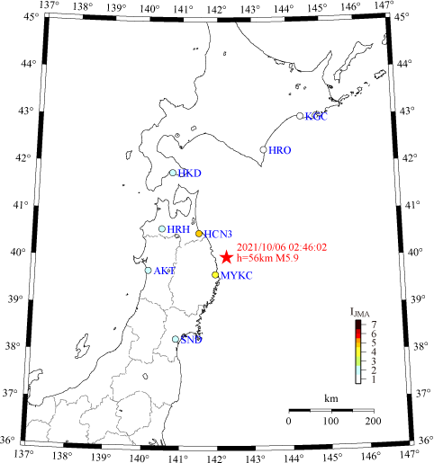
Event
2021/10/06 02:46:02 Off Iwate Pref. Earthquake (M=5.9, h=56 km)
Location of stations
List of records
| Code | Station | Δ (km) | IJMA | Azim. | Loc. | Peak Acc. (cm/s2) | Notes | ||
|---|---|---|---|---|---|---|---|---|---|
| H1 | H2 | V | |||||||
| MYKC | Miyako City Hall | 49 | 4.1 | 165° | 01F | 72.1 | 64.0 | 35.5 | |
| 06F | 229.5 | 88.4 | 77.9 | ||||||
| GL* | 113.7 | 111.2 | 46.1 | ||||||
| HCN3 | Annex, Hachinohe City Hall | 86 | 4.4 | 164° | B1F* | 66.2 | 71.9 | 58.2 | |
| 01F | 70.3 | 66.5 | 49.9 | ||||||
| 10F | 97.2 | 91.6 | 66.9 | ||||||
| HCN | Hachinohe City Hall | 86 | 4.5 | 164° | B1F* | 62.5 | 71.6 | 25.6 | |
| 06F | 211.5 | 169.2 | 51.5 | ||||||
| HRH | Hirosaki Legal Affairs Office | 166 | 2.0 | 195° | 01F* | 3.9 | 4.7 | 2.3 | |
| AKT | Akita Prefectural Office | 186 | 1.6 | 087° | 08F | 11.8 | 16.8 | 2.6 | |
| B1F* | 2.6 | 2.3 | 2.0 | ||||||
| SND | Sendai Government Office Bldg. #2 | 227 | 1.5 | 074° | B2F* | 2.6 | 2.2 | 1.9 | |
| 15F | 5.3 | 5.0 | 4.7 | ||||||
| G40 | 0.1 | 2.2 | 0.1 | ||||||
| HKD | Hakodate Development and Construction Department | 236 | 1.9 | 000° | GL* | 5.4 | 5.1 | 2.9 | |
| HRO | Hiroo Town Office | 268 | 1.4 | 140° | 01F* | 4.1 | 4.1 | 1.6 | |
| KGC | Kushiro Government Office Bldg. | 376 | 0.9 | 167° | GL* | 2.2 | 2.3 | 1.1 | |
| G10 | 1.7 | 1.5 | 0.8 | ||||||
| G34 | 0.7 | 0.7 | 0.3 | ||||||
| B1F | 1.0 | 1.5 | 0.8 | ||||||
| 01F | 1.3 | 1.4 | 0.8 | ||||||
| 09F | 2.4 | 1.9 | 1.3 | ||||||
Legend
M : JMA Magnitude
h : Focal depth (km)
Δ : Epicentral distance (km)
IJMA : JMA Seismic Intensity (of the asterisked sensor)
Azim. : Installation azimuth
H1, H2, V : Peak accelerations in H1, H2 and V directions (cm/s2)